


Hiking Copper Canyon
Page Contents
Hiking Copper Canyon is a misnomer-Exploring Copper Canyon is a more suitable expression
We made 3 hiking trips without guides-1986, 1994, 1995
What is Copper Canyon Exactly?
Copper Canyon, known in Spanish as Las Barrancas del Cobre is a complex of 6 major canyons, one of which happens to be called Copper Canyon. The deepest Canyon is Urique at 6136 ft. Batopilas and Sinforosa tie at 5904 ft. Copper, the most well know is 5770 ft. Tararecua and Oteros are not often mentioned in the tourist brochures.
Together, these 6 canyons comprise a complex of about 28,000 sq miles which is 4 times larger than Grand Canyon Arizona. The extreme difference from top to bottom hosts vegetation ranging from pine and hardwood forests on the plateau to tropical in the canyon bottoms. High rainfall accounts for the greenery and the many miles of rivers that have carved the deep canyons.
Helpful Planning Information
The best season for hiking the canyons is October-November and March. There will be winter snows on the plateau in December-February and temperatures can be quite cold at night although delicious during the day. One must be careful if wishing to hike in the spring as melt waters make the many rivers too dangerous to cross. The summer season would be suffering hot.
Hiking Copper Canyon is not for the inexperienced trekker. It is still a wild place, steep, rugged and exceptionally easy to get lost in as we did on all three of our treks. Trails are still for the local population to get from A to B. They are not well marked; they often end at someone’s plot of land! Trail maps are also a misnomer. John Fayee published a Mexico’s Copper Canyon Country in 1989 with a 2nd edition in 1994 that is said to have topographical maps.
Of course there are guided tours for Copper Canyon. A few companies offer extensive trekking into the canyons. A popular trek is from Rim to Rim. Another is Batopilas to Urique which is one of the three treks we did on our own. But, we did not have the luxury of the map mentioned in this site. Copper Canyon Trails is an American Company offering a variety of guided and supported backpacking and camping trips.
One can also hire a private guide once in Creel but they would be best utilized for day hikes around the area. There are also companies that offer tours of the various towns and sights in the area. They use jeeps and other vehicles and perhaps offer a local short hike in the area visited.
For map images of Copper Canyon, Mexonline.com has a variety of views that can help put the canyons and towns in relationship to each other.
Where is Copper Canyon?
Located in the Mexican State of Chihuahua, the rivers of the Copper Canyon complex carved over 10,000 miles of canyons through the Sierra Madre Occidental Mountains.
Creel in the Sierra Madres is the tourist town that services Copper Canyon. Other towns of interest to tourists and hikers in the area are Divisidero, Bahuichivo, Cerocahui, Batopilas and Urique.
The closest big city is Los Mochis on the coast and Chihuahua, the capital of the state of Chihuahua. Most tourists have heard about the famous train ride on the Chihuahua al Pacífico Railroad that goes between the two cities.
There are numerous choices for getting to Copper Canyon and of course, a multitude of activities to do once you get to the area.

The Tarahumara of Copper Canyon
No visit to Copper Canyon should be complete without recognizing the importance of the Tarahumara Indians who have populated these steep canyons for the last 500 years. They have consistently resisted being forced to change, first by the Spanish, then by Mexico, and still by foreigners.
The Tarahumara continue to live in traditional villages and follow traditional customs and dress.


Traditionally the Tarahumara are a shy people. They express no need to meet people from the outside world. “How long are you staying?” one man asked us after we spent a few days in his village. He wanted to know if we were going to be there long enough to make our acquaintance worthwhile!
Before heading into the canyons, we purchased a book of their language and learned a few important phrases and greetings.
It made a tremendous difference on how they received us.
Tarahumara Christmas Celebration
Virgin of Guadalupe Festival
The Jesuits made the greatest inroads into Tarahumara culture. But, the Tarahumara took the ceremonies and flair and kept their own beliefs.
Every Christmas and Easter is a special time to celebrate at the local Pueblo Churches.


Hiking Copper Canyon-1986
Creel to Divisadero
We had just finished a full summer of teaching and guiding Outward Bound Courses in the Boundary Waters Wilderness of northern Minnesota. We were prime for a vacation of our own making and had been eyeing the wild canyons of Las Barrancas del Cobre. It was late October, a perfect time to escape the coming cold season and go south.
Having never been to Copper Canyon, nor having found much information about hiking the canyons, our vacation turned out to be another adventure to top our growing list of near foolish accomplishments!

Creel Copper Canyon Mexico
We drove to Creel, the main tourist enclave for information about the canyons.
In 1986, maps of Copper Canyon were mostly empty spaces. A few hiking trails may have been drawn on them, but we came to the conclusion they were wishful thinking on the part of the cartographer.
Financially, we could not even consider hiring a guide or going on a tour.

We did not have a GPS.
Indeed, the first consumer level GPS did not hit the market until 1989.
We barely had a map.
We have no idea where we went and cannot share our route with you.
But, we hope the photos will provide you with the inspiration to go hiking in Copper Canyon someday yourselves. It is a rich experience, full of surprises, even if you go with a guide service or use a GPS today.
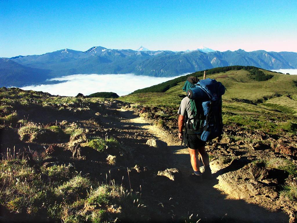
We hike the canyon rim the first two days.


The Rim is forested with Pine and hardwoods. We saw lots of felled trees being ax cut into lumber. Limbs were used for fencing or burned for fuel.


We carried a dutch oven for baking bread with dehydrated fruit and nuts. The result, high in carbohydrates, protein and sugar, was our dinner and lunch for the next day.
Each day, we passed a hut or fenced shelter for goats, or a corn patch.
When we’d meet the owner, he would keep us pointed in the right direction.
They knew the trails.
We were glad we had learned some of their language. Once we greeted them according to proper custom, they were very friendly and helpful.

We approached the rim again, and peered down into the immense canyon. That was where we were going!


It took us a whole, painful day to descend to the river. A 5000 foot descent is tough on the knees and feet, especially with a heavy pack. Still, we saw fields of corn and shelters on the way down. The canyon walls supported ledges here and there where the Tarahumara farmed.
The farmer on this plateau led us to the descending trail. He and his burro were going to the other side. He had a cornfield over there that also needed attention. The trail was wide, winding straight down the side of the canyon. Who built this trail? How? His burro and he passed us up quickly. He walked in his huaraches…sandals hand made from old tires.


About halfway down, we rounded a corner and saw the river below.

It seemed like such a simple task. Follow the river downstream until we came to the spot we marked on our map that appeared to be the location of a major trail ascending to Divisadero.
Every one we talked to assured us it was there!


We found our trail after two incredible days bouldering our way down river. It was in the canyon we had marked on the map. It took a bit of hunting to find the start. It was buried in thick thorn brush.

We soared upward on a built path that imitated the Inca Trail. After two hours of climbing, every step on an engineering miracle, it ended.
High above the river…it just ended. A barricade of sticks and brush unceremoniously cut us off from our goal.

Sadly, we descended back down to the river. We had no other option. The trail was built into a cliff. There were no exits.
Okay, we said, maybe it’s in the next canyon downstream. After spending another night on the river, and searching every nook and cranny downstream,
we decided either the trail did not exist, or we were too lost to find it. We would have to climb out.


We were running quite short on food.
We had planned 6 nights and seven days.
It was time to bail.
We scoured the canyon walls until we found a possible route. There were ledges!


It took us two days to climb out.
We did not have enough water containers.
We dug in the ground to find a source.

How could one imagine that we would come out right at the Divisadero station. When we topped out, we located the trail. It came up from much further downstream than we figured. We kept this tidbit of information tucked away for another trip!
Hiking Copper Canyon-1994
Creel to Divisadero


This is our second excursion to Copper Canyon. It didn’t take much for our Swiss adventuring friends to join us on this escapade. We sent them the photos from our first efforts! We started out from Creel again, but in a different direction. We were going to try for Divisadero to see if we could find it this time.
We had different information, but once again, no GPS and poor maps.
We found the Divisadero trail we were looking for the first time, but it was not an easy effort. Nothing is at it seems in Copper Canyon.
A first day hike out the rim brought us to a beautiful campsite along the edge for our first night.

Next morning, the search begins for the descending route that we hope to find.
The maps are inadequate; the print is tiny.
There are no trails marked on it.
We are reading the topography.
What we do find is a tolerable route on long ridges.

The ridges we follow are open, exciting,with a large dose of mystery and magic.


We come to a flat spot that is good for camping. The goats think so too.


The evening view spot is pretty special.


The next day we find more good ledges and ridges. We are about halfway down to the river.


Our ridges and ledges got us safely down to the river for another incredible camping spot


Three days we work our way down river. We have to cross at least four times a day because of cliffs.


We think we see a trail leading up out of the canyon bottom. Can this be the route to Divisadero? We give it a shot.


We find pieces of definite trail, but nothing all that reassuring.
There are times when it is a battle through brush.


A Tarahumara boy has spotted us. He doesn’t need a trail. He races down the cliffs to sell us his apples!
Where did he come from?


It is several more hours of the same…
“yes it is”…,
“no it isn’t” thinking
when we finally come to a real trail…with footprints!


This is the Tarahumara village we needed to find. It is at the base of a very big trail that ascends steeply to Divisadero. The people in the village are making and selling their crafts to the tourists who venture down the trail from the train station. It is an important source of revenue for them.
We spend an hour or so with them. The head man speaks some English. He is the spokesperson for the village and intermediary with tourists.
Yet, we are the only tourists to come to this village this week.


The Tarahumara are skilled crafts people. They have been making their own products from the forest for centuries.
Now, they have been encouraged to market their fine work in their villages and in Creel.

From this village, it is a well built path to Divisadero on the rim. For us, after exploring the canyon bottom, and finding a difficult but reasonable route back up, the path was a treat.
We all had our souvenirs from the village. It was a successful exploration. We did not get too lost, nor have any challenging climbs out like on our first journey.
It set the scene for another exploration to come.

Hiking Copper Canyon
Batopilas to Urique-1995

Hiking Copper Canyon is not normal hiking. Without a guide, it is an adventure with definite possibilities of getting seriously lost. Yet, this is our third time exploring the canyons without a guide service. Needless to say, we got seriously lost on the first two occasions!
On this trek, we actually hiked a good trail from start to finish. No bouldering, no scrambling, no getting lost. Although the trail is not marked with any signage, it is a well established route through villages in the canyons. It begins in Batopilas, at the bottom of Batopilas Canyon and crosses over the mountains to the town of Urique in the Canyon of the same name.
We actually had a map as well that we purchased in the Creel store: INEGI Topographical 1:50,000 Batopilas G13A41.
Getting to Batopilas is an adventure all by itself. It is not for the faint of heart. We happened to drive our van to Mexico, so we drove to Batopilas. Fifty-five kilometers were on rough dirt road. The 31 switchbacks in the adjacent photo were brake burning steep and threateningly narrow. A public bus from Creel takes 5 hours. Or, one can journey to Batopilas with a tour company and save a lot of stress! A popular company operating out of Creel is 3 Amigos. This is their photo!


Batopilas was founded by the Conquistadores in 1632!
The Conquistadores explored and established for one reason only: to secure wealth. The Batopilas area was extravagantly rich in silver. It began as a mining town. Today, the silver is gone, but Batopilas remains a destination in itself as a once famous colonial town in the absolute middle of nowhere! Now, it is a destination for adventure seekers.

When we arrived in Batopilas, we drove another 4 miles to the Satevo Mission.
We wanted to visit the 17th century church before starting the hike.

The 30 mile trail to Urique begins north of town just beyond the old dam. It follows the picturesque Cerro Colorado Arroyo and river of the same name.


After hiking about 2 hours, we enter a tiny hamlet. It’s a very busy place for being so far up valley. There were several houses under construction. Like many remote small villages, most of the materials are made on the spot.


We move on from the village to a river crossing. The cool shade, water source and a handy flat spot make a good camp site. There is a lot of activity passing by, including a burro train. All the cowboys are carrying automatic weapons!


We waved as they went by.
They waved back!
The next morning, another pack of burros comes up the trail from the river. They know where they are going. The cowboy is still back at the river watering his horse and the burros are moving…until they see us! They stop dead in their tracks and cast a wary eye. Obviously, we smell different!

Shortly after our river camp, we start ascending upwards towards Cerro Colorado.


Like all climbs in the Copper Canyon, the ascent out of Batopilas Canyon is about 5000 ft vertical. But, after our other adventures, this ascent was pleasurable and quite easy. Not only did we have a great trail, but it went in stages with a variety of plateaus. Our favorite was when we entered the oak and pine forest and grasslands with cactus.

A small Rancho sat alone in an open field. The family came out to greet us. They knew the routes to Urique and advised us to take the longer one following the high country before dropping over the rim. Being in no hurry, we accepted their gracious invitation to camp for the night.


The next day, we ramble up and down, gaining glimpses of Urique Canyon here and there.


We come to the descending trail, but cannot bear to leave such a beautiful spot. We camp on the edge.

The descent is long and steep. Our feet don’t like being jammed against the front of the boot all day, so we don our sandals.
Felix bought a pair of Tarahumara sandals made from old tires. He had been wearing them the entire trip!


The Urique River is a busy place. We are not too far from the town.


We pass another interesting Rancho where a lot of locals seem to hang out. We joined them on the bench in the shade. Pretty soon, our packs were on different backs. One young lady was completely dwarfed by Felix’s giant pack!


But these two gentlemen seem to have had their own agenda.
They never spoke.
The kid on the horse kept a watchful eye on us!
The man on the fence kept his gun well in sight.

Urique did not have the charm of Batopilas. Squeezed by canyon walls, the one main street was long and narrow and lined with the typical concrete buildings.

But, it had a fabulous store with wonderful fresh fruit!

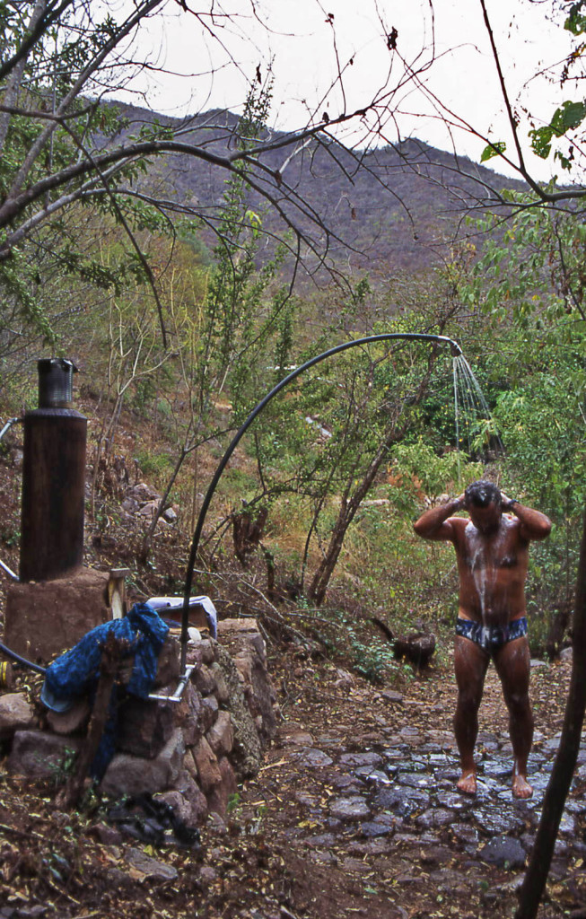
And a place to camp had a shower!
What more could a person ask for after a fabulous trip hiking Copper Canyon, Mexico?
How about a New Year’s Eve celebration with live guns and ammunition firing all night long!


Copyright Material
All rights reserved. No part of this page may be reproduced or utilized in any form by any means, electronic or mechanical, including downloading, print screen, photocopying, recording, or by any information storage or retrieval system, without the prior written permission by the copyright owner.